

Before
After
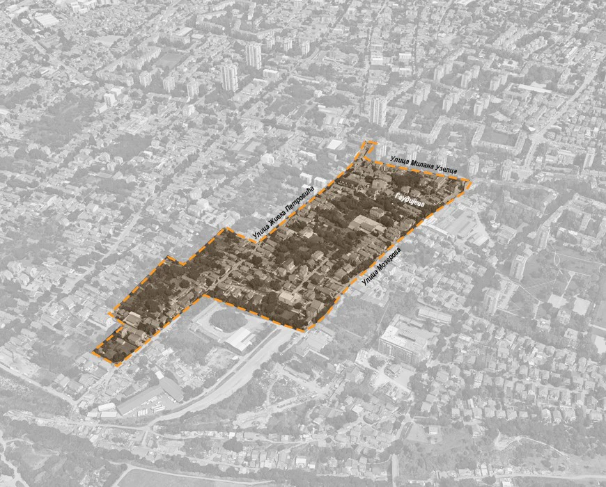
The plan defines areas for public and other uses: • Road network: The primary road network includes existing secondary streets Zivka Petrovica, Milan Uzelac, and Mozerova, while residential access streets and utility paths form the secondary network. • Green spaces: Green areas with tree-lined pedestrian paths are planned along the utility path connecting Milan Uzelac and Prvomajska Streets. Existing tree lines along Mozerova and Zivka Petrovica will be preserved as part of the road infrastructure.

.svg)


The Upper Zemun area, which includes the site covered by this plan, has been undergoing transformation for several years. Since the establishment of the commercial street (Prvomajska Street), there has been growing interest in constructing multi-story buildings exceeding the height of P+2+Pk (ground floor + 2 floors + attic). The increase in population and activities has led to diverse types of housing, ranging from small individual homes to luxury villas. This area is characterized by a traditional urban layout with an orthogonal street grid forming large, elongated residential blocks mostly bordered by single-story houses on deep plots. Inside these plots, gardens and orchards dominate, although there is a growing trend of residential construction adjacent to existing buildings. Within the plan boundary, four types of land use are identified: • Public uses: streets and utility facilities • Other uses: residential, commercial activities, undeveloped and unregulated areas More than half of the area consists of developed residential parcels. Buildings are located along existing streets and appear in continuous, interrupted rows, or as free-standing structures. Buildings situated deeper inside the plots have unique access roads. Building heights range from a single story to five stories (P to Su+Vp+2+Pk). Higher building heights are observed along Milan Uzelac Street and at the intersections of Zivka Petrovica and Mozerova Streets with Milan Uzelac. Commercial activities are also present, including 43 businesses such as manufacturing, utilities (electricity, gas, water), construction, retail trade, motor vehicle repair, transport, storage, real estate activities, rentals, and various professional services.
A combined children’s facility (KDU) with a capacity of up to 270 places is planned within Block 10. Due to the elongated shape of the block and the requirement for separate parking, parking areas will be located along the block’s perimeter. • Residential areas occupy the majority of the plan’s territory and include existing and planned individual housing. • Construction of residential buildings is permitted with accompanying compatible uses (up to 20%), including small-scale production facilities such as bakeries and pastry shops, technical services, commercial premises (trade, hospitality, tourism, crafts, business and financial services), as well as cultural, educational, healthcare, childcare, and social care facilities. • Commercial activities are planned in Block 2 on the site of an existing production facility. As these areas are surrounded by residential buildings, their transformation into housing is allowed. Zones are defined according to building typology, with specific regulations on allowed building height, site coverage, and built-up area. Minimum percentages of green space in direct contact with the ground vary by zone: • Commercial zones: minimum 20% • Residential zones: minimum 30% or 40%, depending on the specific area This plan supports sustainable urban development by balancing housing needs, commercial activity, and green space preservation, ensuring functional connectivity and maintaining the area’s traditional urban character.


