

Before
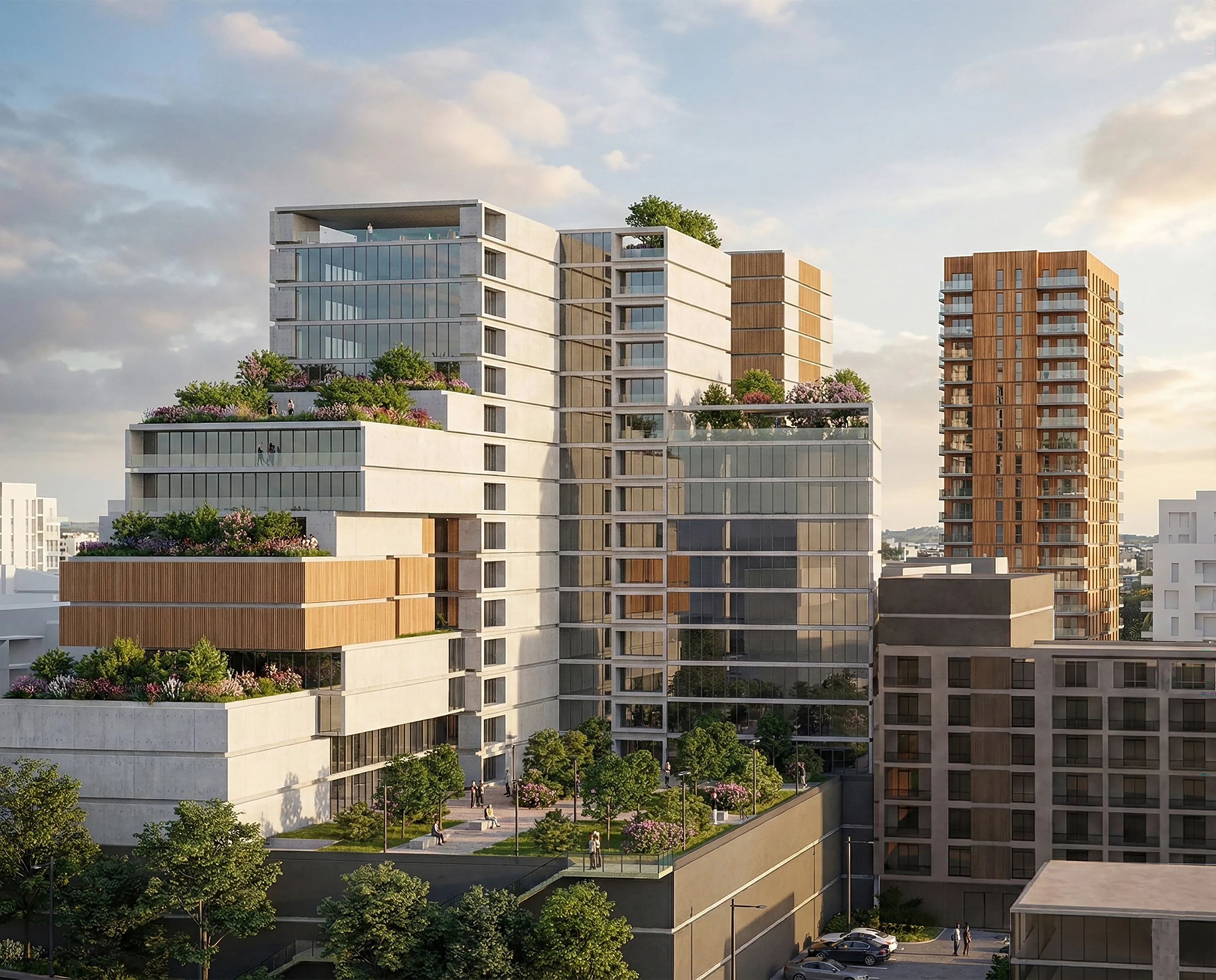
After
In the initial phase, the possibility of individual, uncoordinated development of plots was considered. Such an approach would result in a non-functional urban unit — spaces would remain underutilized, and the creation of quality public areas would be hindered due to the obligatory fencing of plots. This would further restrict the development of the communication network, particularly pedestrian pathways within the block and in relation to the surroundings, failing to meet the basic conditions for a high quality of life for future users. Through the analysis of various alternative solutions and development scenarios, an optimal model of spatial organization was established. The chosen concept includes lower plot coverage, greater building height, and the possibility of cascading design, which allows for the creation of attractive public spaces, green roofs and ground-level landscaping, as well as micro-environments with varying levels of privacy. The network of open spaces, free from physical barriers such as fences, contributes to higher quality social interaction and better urban connectivity. The proposed high-rise building, together with the existing "Red High-Rise" (Crveni soliter), defines a new spatial landmark for the city. This not only enhances the identity of the area but also provides users with a modern and comfortable environment featuring optimal natural ventilation and sunlight exposure within the block. To validate the quality of the chosen planning solution, numerous expert analyses were conducted: a traffic study, an assessment of the capacity of educational institutions, an evaluation of the criteria for high-rise construction, as well as studies examining the ecological and sociological contributions of the solution to the development of the local community. Special attention was also given to analyzing the feasibility of implementing the plan in accordance with existing legal and technical frameworks.

.svg)


The planned area covers the location along Darvinova and Brace Jerkovic streets, in the municipality of Vozdovac. The area covered by the planning document is partially undeveloped, while the existing buildings—mainly residential and commercial—were constructed without planning regulation and built illegally. The proposed solution is the result of a thorough analysis of spatial potential, user movement, and possibilities for greening the urban environment. The goal of the planning was to create a functionally connected urban unit, while defining a new spatial landmark that contributes to the identity and quality of the broader urban environment.

The analysis of possible implementation methods was carried out with the aim of forming a planning solution for the area between the following streets: Nova Kumodraska, Darvinova, and Brace Jerkovic, within the Vozdovac municipality. The analysis examines spatial layout and compositional planning, the movement of users — both vehicular and pedestrian — the creation of gathering places and green islands or corridors, in order to create, to the greatest extent possible, a high-quality and functional space that provides the necessary comfort for users. Through the exploration of this relationship, solutions were formed where the liberation or occupation of publicly accessible open spaces influences the improvement of spatial quality. During the development of the analysis, three variants were examined: Uncoordinated (sporadic) construction Block-based solution through compositional planning Redistribution of content Variants 1 and 3 were presented, as it was determined during the process that variant 2 does not represent a satisfactory solution or a significant improvement for the subject location.
The analysis covers the eastern part of Block “3,” located at the corner of Darvinova and Brace Jerkovic streets. It examines the feasibility of constructing high-rise buildings intended for mixed residential-commercial use, with heights ranging from ground floor + 9 (GF+9) to GF+16, or approximately 35 to 60 meters.In addition to the site itself, the analysis includes a spatial and programmatic review with a conceptual design, as well as a planning proposal that provides height regulation. Within the zone boundary, the construction of one or more high-rise buildings is planned, interconnected by annexes. Depending on the building’s massing and distance from neighboring plots, it is possible to develop either two high-rise buildings with lower annexes, or a single building with two linear wings (aligned along the bordering roads), designed in a cascading form, where the height decreases from the street corner toward the plot boundaries. The buildings are primarily residential, with ground floors intended for commercial or business-commercial purposes. The site is favorable in terms of physical characteristics (area, shape, dimensions), the positioning of buildings on the plot in relation to adjacent structures and parcels, and its potential contribution to the public realm (open public spaces of greater attractiveness and urban character are planned). The location also benefits from good transportation accessibility. The planned high-rise building can be seen as a counterpart to the existing "Red High-Rise" (Crveni soliter), contributing to the urban ambiance and modernizing the overall urban and architectural image of the area. In addition to evaluating the criteria for the construction of a high-rise building, an assessment was made of the project's contribution to eco-sociological development. The findings indicate that the application of green infrastructure is mandatory in order to enhance both the ecological and sociological aspects of the site’s usage.
The Study on the Contribution to Eco-Sociological Development is a key component of the planning document, aimed at reviewing and validating the proposed urban design solution. Given that a high-rise building is planned for the site in question, this study serves as a tool for examining potential development strategies, refining the selected concept, and identifying any necessary site-specific restrictions. The first phase of the study involves identifying and mapping existing environmental pollutants located on or affecting the site, particularly in relation to users' quality of life. Once this mapping is complete, the next step is to highlight areas requiring further focus during the detailed planning phase. The location is surrounded by major roads, such as Darvinova Street and Braće Jerković Street, which are identified as primary sources of pollution. The next step is to map and evaluate the existing greenery in the area, with the goal of preservation, transformation, and landscape enhancement. Based on these assessments, the study proposes a landscape solution that defines various types of greenery. The typology of planned green areas is further defined and evaluated through tables that detail their impact and contribution to the site. Within the designated area, the following green infrastructure is proposed: Protective green belts functioning as environmental buffers Low- and medium-height vegetation zones Tree-lined avenues Areas with semi-permeable ground surfaces A network of pedestrian pathways with defined nodes—spaces intended for social interaction and gathering


