

Before
After

.svg)


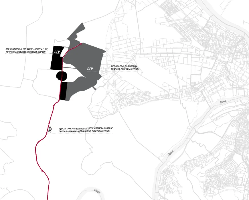
The three subject Plans are located in Dobanovci and cover a total area of 1,887 hectares. The goal of these Plans is to regulate the settlement, establish a new industrial zone, and provide transport and infrastructure connections between the designated areas and their surroundings. GUP DOBANOVCI The subject Plan encompasses part of the cadastral municipality of Dobanovci, within the municipality of Surčin. The planning document defines three units—A, B, and V. Unit A – Settlement occupies the largest portion of the construction area, positioned between the state road IA A3, the Galovica Canal, and Beogradska Street. The primary land use of this unit is residential, while some parts retain their current uses, such as public service facilities. Additional public, commercial, and small industrial buildings are also planned. Unit B – Motorway South covers the area between the state road IA A3, the municipal road “Sremska Gazela,” and the Galovica Canal. This unit is divided into sub-units: a commercial complex and an industrial complex. Unit V – Motorway North includes the construction area north of the motorway, along state road IIB 319, designated for industrial use. The fundamental premise of this Plan is to transform the settlement from a rural type into a settlement of a significant economic center of the municipality, featuring developed urban, economic, and social characteristics within the municipality of Surčin and the City of Belgrade. The focus is on creating spatial and functional preconditions for economic development, which also entails the development of public service facilities, housing, public spaces, and accompanying communal infrastructure. Elements of transformation and urban development are reflected in the definition of new construction zones and the creation of planning possibilities for new industrial and commercial complexes. The economic, industrial, and urban development of Dobanovci represents a key part of the overall development potential of the municipality of Surčin, contributing to the broader economic prosperity of Belgrade and the region. The planned transport and utility infrastructure serves all designated land uses and forms part of the comprehensive system of the municipality and the city. Accordingly, it is necessary to make full use of the existing built structures, the settlement’s location, and the developed road network. This planning document defines measures and conditions for environmental protection and improvement, ecological revitalization, and the preservation and enhancement of natural and cultural heritage. GUP BD AGRO The area covered by this planning document is the “BD Agro” complex, which consists of three zones—A, B, and C, located within the settlement of Dobanovci, municipality of Surčin. The purpose of this Plan is to elevate the urban level of the area through an analysis of existing conditions, assessment of spatial and functional potentials, and evaluation of current land use and buildings. The Plan reexamines urban planning elements and defines the minimum requirements for current and future land users. It also establishes the division between public and other construction land, defines the building zones, and creates planning opportunities for new industrial and commercial complexes. Furthermore, the Plan defines the conditions for functional connections with existing and planned national-level transport corridors, the road network defined in the Spatial Plan of the Municipality of Surčin, and the associated infrastructure systems and facilities. The designated land uses include industrial and commercial activities, as well as other related purposes. PDP SREMSKA GAZELA The scope of this planning document refers to the route of the municipal road “Sremska Gazela” Progar—Bečmen—Dobanovci, within the municipality of Surčin. The Plan defines the conditions for functional connections with existing national road corridors, connections with existing and planned road networks and complexes along the route, corridors, and all technical elements of the roadway to ensure smooth traffic flow and the functionality of planned infrastructure systems. It also establishes the public interest through the designation of public-purpose land parcels. The area covered by the Plan is divided into three units – I, II, and III. Unit I: transport and power infrastructure. Units II and III: transport, power, and water management infrastructure.


